FOR RENT
---------------------------------------------------------------------------
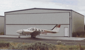
T Hangar 1035 square feet. 42 foot electric Bi-Fold Door. Water, electric, snow removal, and Common Restroom included.
SHOOK executive hangars 641-0460
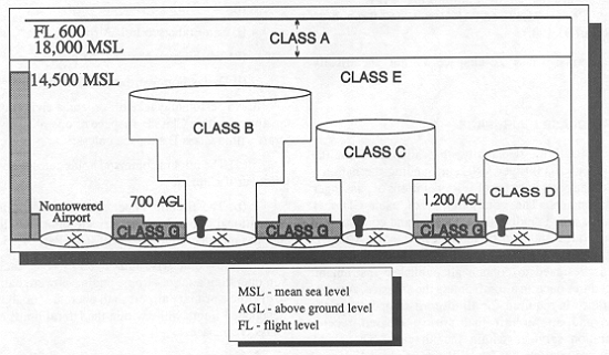
Basic VFR Weather Minimums
Airspace Flight Visibility Distance
from Clouds
Class A
Not Applicable
Not Applicable
Class B
3 statute miles
Clear of Clouds
Class C
3 statute miles
500 feet below
1,000 feet above
2,000 feet horizontal
Class D
3 statute miles
500 feet below
1,000 feet above
2,000 feet horizontal
Class E
Less than 10,000 feet MSL
3 statute miles
500 feet below
1,000 feet above
2,000 feet horizontal
At or above 10,000 feet MSL
5 statute miles
1,000 feet below
1,000 feet above
1 statute mile horizontal
Class G
1,200 feet or less above the surface (regardless of MSL altitude).
Day, except as provided in section 91.155(b)
1 statute mile
Clear of clouds
Night, except as provided in section 91.155(b)
3 statute miles
500 feet below
1,000 feet above
2,000 feet horizontal
More than 1,200 feet above the surface but less than 10,000 feet MSL.
Day
1 statute mile
500 feet below
1,000 feet above
2,000 feet horizontal
Night
3 statute miles
500 feet below
1,000 feet above
2,000 feet horizontal
More than 1,200 feet above the surface and at or above 10,000 feet MSL.
5 statute miles
1,000 feet below
1,000 feet above
1 statute mile horizontal
NOTE: VFR minimums 1000' ceiling for
landing and takeoff in controlled airspace.
3-1-5.
VFR Cruising Altitudes
and Flight Levels
(See TBL 3-1-2.)
TBL 3-1-2
VFR Cruising Altitudes
If your magnetic course
(ground track) is: (A)
And you are more than 3,000 feet above the surface but below 18,000 feet MSL, fly: (B)
(A) 0° to 179°
(B) Odd thousands MSL, plus 500 feet
(3,500; 5,500; 7,500, etc.)
(A) 180° to 359°
(B) Even thousands MSL, plus 500 feet
(4,500; 6,500; 8,500, etc.)
Meadow Lake Airport Cameras
AFTER YOU CLICK ON ONE OF THE CAMERA'S
Choose sequence: 1 HOUR LOOP
2 HOUR LOOP or 4 HOUR LOOP
for a time lapse of the passing weather.
You can spot weather trends and see direction of movement. Click on High Resolution Image for a very large current picture of the selected camera direction.